Temperature, Precipitation, Air Quality, and Mosquito Activity
Forecasting the Weather
By Terry Elrod
(updated 2023-07-28)
This report provides information useful for forecast the weather, ranging from monthly climate data to animated 6-hour forecasts. Links and examples are provided. They are ordered from the longest time-scale (climate), to three-month forecasts, one-month forecasts, weekly forecasts, and current (often real-time) information. Included are forecasts for temperature, precipitation, air quality and mosquito activity.
If you are using an electronic copy, you may click on any one of the eighteen links in the document. All complete link addresses (also clickable) are given as footnotes at the bottom of each page.
You can also download this report and print it or save it to your device. The links are clickable.
Contents
- On-line information about climate
- Long-range forecasts from Environment Canada
- Seasonal forecast for temperature
- Seasonal forecast for precipitation
- Monthly forecast for temperature
- Five-day forecasts and weather warnings from Environment Canada
- Real-time information on weather and air quality (provided by Ellen Homola)
- Animated map of precipitation for the coming six hours
- Map of current air quality
- Mosquito activity in Edmonton
On-line information about climate
Most Albertans have a fairly good idea of what weather to expect for each month of the year, but Environment Canada provides exact numbers for many locales. Alberta locales are listed on-line here.
The ones most pertinent to the Waskahegan Trail (presented in the order given by the WaskaheganTrail Guide Book) are Edmonton, Leduc, (not Wetaskiwin, unfortunately), Camrose, Tofield, and Fort Saskatchewan.
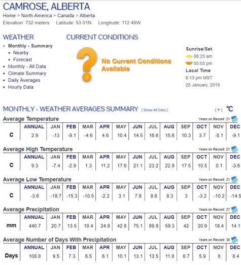
Here’s part of what is displayed for Camrose on 2019-01-25. Both annual and monthly data are shown. We can see from this table, for example, that in Camrose
- July normally has the highest daytime temperature and the most rain.
- August is as warm as July but has 1/3 less rain.
- Over all non-winter months of the year, the amount of rain changes from month to month much more than the number of rainy days with rain.
Long-range forecasts from Environment Canada
Long-range forecasts predict to what extent the coming temperature / precipitation will be above normal or below normal for the coming month or longer for every part of Canada. (What is “normal” is defined by climate. See above.)
Environment Canada uses current weather and climate data, together with sophisticated forecasting models, to generate forecasts for temperature and for precipitation. These forecasts come in many different forms, but three of are special interest to us.
- Two Seasonal (three-month) forecasts predict average temperature and average. These forecasts are updated on the last day of every month.
- Monthly forecast predicts temperature for the coming 28 days. It is updated every Thursday, giving the forecast for the four weeks beginning the following Monday.
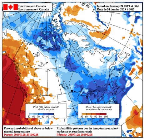
Seasonal forecast for temperature
Click here for the current forecast.
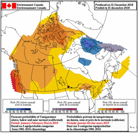
Below is shown the three-month temperature forecast as of 2019-01-25. (It covers January, February and March.) The closer to red, the hotter relative for normal, and the closer to blue, the colder. We see that all of Canada except the northeast is expected to be warmer than normal for this period.
Seasonal forecast for precipitation
Here’s the three-month precipitation forecast as of 2020-01-31. (It covers January, February and March.) The areas in green are expected to be wetter than normal, while those in orange-red to be drier. All of the white area is expected to be near normal.
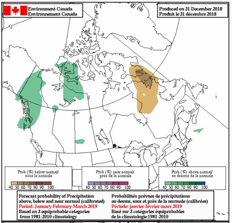
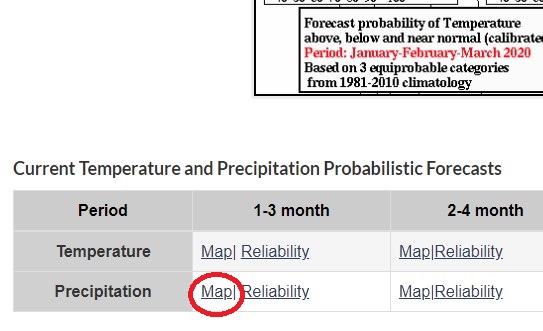
To get this forecast, click on the link for the seasonal precipitation forecast (here) and then click on the link labelled Map that appears right below the temperature map. (You may ignore all maps except the one at the top of the webpage.)
Monthly forecast for temperature
Click here for the current monthly forecast.
Shown below is the monthly forecast as of 2019-01-25. We see that BC is expected to be warmer than normal, and all of Canada east of Saskatchewan is expected to be cooler. The Waskahegan Trail will be about average or perhaps a little warmer.
Five-day forecasts and weather warnings from Environment Canada
While monthly and seasonal forecasts and climate data are useful for longer-term planning, nothing takes the place of more current information (especially weather warnings). Environment Canada provides weather reports and forecasts online for 72 Alberta communities and by telephone for 71 communities (leaving out St. Paul). Online forecasts for 275 Alberta communities are provided by Weatherbase. The following table shows the online and by-phone information available for all communities along the Waskahegan Trail.
| Locality with online weather information from Environment Canada or Weatherbase websites. To obtain a local forecast by phone, dial 1-833-794-3556 (for English), or 1-833-586-3836 (for French) and – | ||
| Environment Canada | Weatherbase | then enter the code … |
| Edmonton | Edmonton | 07050 |
| Edmonton International Airport | 07071 | |
| Wetaskiwin | 07009 | |
| Gwynne | ||
| Camrose | Camrose | 07018 |
| Elk Island National Park | 07063 | |
| Fort Saskatchewan | ||
Real-time information on weather and air quality (provided by Ellen Homola)
Also, see immediately above to learn how to get weather warnings.
Animated map of precipitation for the coming six hours
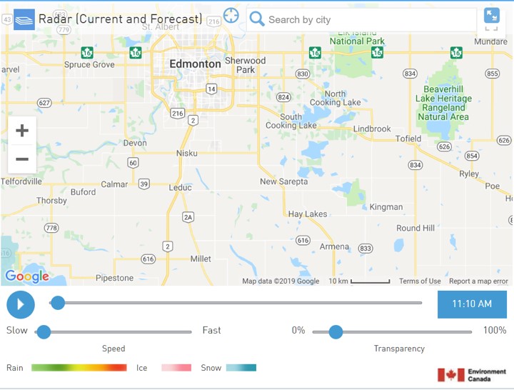
An animated map of precipitation expected for the coming six hours is available from the Weather Network (using information from Environment Canada). Clicking here shows the map centred on the Waskahegan Trail.
Below is an example for 2019-03-27 at 11:10 AM. It shows current conditions. Clicking on the “+” or “–“ symbols that appear in the map at the left allows you to zoom the map in or out. Clicking anywhere in the map and holding the click while moving the mouse allows you to re-centre the map as you please.
Shown along the very bottom are the colours used to portray rain, ice and snow. Looking at this map shows only a tiny area with light snow — at the very bottom left corner, where you find the “G” in “Google”, and just above it.
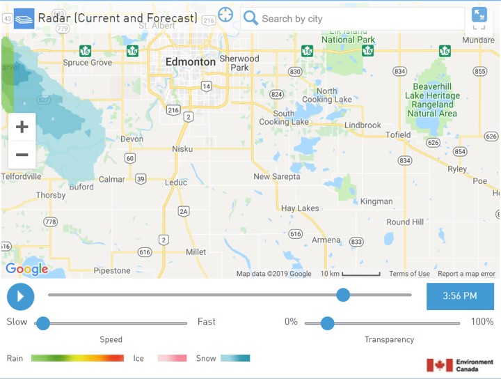
Clicking the blue circle with a while triangle (right below “Google”) starts an animated portrayal of the expected precipitation for the coming six hours. Here’s what the map looks like for this date about five hours later. You can see that snow is expected to move in to the area southwest of Edmonton, reaching as far southeast as Buford and Calmar. Such information can be very timely when you’re just about to head out for the trail.
Map of current air quality
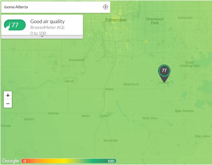
The website Breezeometer.com provides a map of air quality. Click here and then, at the top left of the screen in the box that says “Type street address,” you may type any destination you wish. Typing in “Looma Alberta” centres the map on the approximate centre of the Waskahegan Trail. After doing this and then twice clicking on the “–“ sign to zoom out gives the following air quality conditions for our trail (on 2019-03-27 at 11:50 AM).
Mosquito activity in Edmonton
AccuWeather forecasts daily mosquito activity for the coming seven days for:
- Edmonton (https://www.accuweather.com/en/ca/edmonton/t5j/mosquito-activity-weather/52478),
- Wetaskiwin (https://www.accuweather.com/en/ca/wetaskiwin/t9a/mosquito-activity-weather/52070),
- Camrose (https://www.accuweather.com/en/ca/camrose/t4v/mosquito-activity-weather/51987), and
- Fort Saskatchewan (https://www.accuweather.com/en/ca/fort-saskatchewan/t8l/mosquito-activity-weather/52058).
To look for mosquito forecasts for any locale, first search for the location. Once found, right below the location name is a horizontal menu bar. Swipe the menu bar to the left until it shows “HEALTH & ACTIVITIES”. Click on this and the scroll down until you see “Mosquitos”. Clicking on this reveals the forecasts for the coming seven days.
To learn current air quality, return to the horizontal menu bar shown under your chosen locale and click on “AIR QUALITY”.
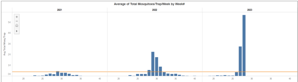
In addition, the City of Edmonton traps mosquitoes in season, counts them, reports their weekly counts in graphs, as well as providing other relevant information. (See https://www.edmonton.ca/programs_services/pests/edmonton-mosquito-activity.) For example, here is a graph comparing the current year’s mosquito numbers to past years. For example, the following graph (from https://public.tableau.com/app/profile/city.of.edmonton/viz/MosquitoCO2TrapData/MosquitoCO2Trapwebsitestats) shows weekly mosquito counts for 2023 (on the right) up until week 28 (the week when this document was revised) compared to the prior two years. Yup, August 2023 is indeed an especially bad month for mosquitoes!
May the weather be kind to Central Alberta,
to the many landowners who make the Waskahegan Trail possible,
and to you!
To comment on this document, please contact the author (Terry Elrod) at terryelrodAB@gmail.com or at 780-432-3557. And be sure to visit the website of the Waskahegan Trail Association, at https://waskahegantrail.ca/.